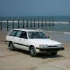
October 30, 200718 yr Saturday I got to take my first drive into the Jocassee Gorges natural area. This is a large tract of land in NE South Carolina, and is home to a number of unique plant species....and miles of dirt and gravel roads. Most of these roads are closed seasonally to reduce impact on the terrain and the wildlife. So, now that they're open for the fall, it was a great opportunity to go on an adventure with my young son. The roads were really in pretty good shape. There was no need for 4wd (although I put her in 4 a couple of marginal places because I wanted to), and the ground clearance of my stock height Loyale was sufficient, although I had to be careful a couple of places. The speed limit is set at 15mph on these roads, and most of the time that was a comfortable yet fun speed, especially considering the curves. Here is a nice shot of Jacinta in a deeply hillside along Horsepasture Road. The fall color is not great this year due to the drought we've been having, but there were a few spots that were quite pretty. Here is one of them. Although these are mountain roads (Southeast Mountains, that is), there are not many places with views. But we stopped to enjoy this one. It was a good photo op too. Our destination was Jumping Off Rock, a cliff approximately 100 foot high that overlooks Lake Jocassee. This is about 10 miles in from the paved road, and the view is worth the trip all by itself. Here's a panorama I stitched together from 3 photos We took a different route home, and at one point we had the choice of a bridge, or not a bridge. Somehow the bridge didn't seem to get much traffic . I hope to get back someday soon to explore more of the many roads and enjoy the mountains and woods.
October 30, 200718 yr I'll have to check that out! Looks like a fun ride, and just a few hours away.(I'm in central NC) Good lookin loyale too.
October 30, 200718 yr wow.. that looks great. i'm in atlanta, georgia and that doesn't seem like too far of a drive.. can you tell me how to get there? or about where it's located? thanks!
October 31, 200718 yr Author The area is west of Highway 178 and north of Highway 11. The SC DNR site is here: http://www.dnr.sc.gov/managed/wild/jocassee/index.htm But you have to wade through a bit if stuff to find out the specifics. A more useful writeup of the route we took is here: http://www.southcarolinawildlife.com/pubs/septoct2006/jumpoffrock.html Google maps has also been interesting to look at, and topozone.com (although at least the free maps are woefully out of date)

Please sign in to comment
You will be able to leave a comment after signing in
Sign In Now