
Leaderboard
-
pontoontodd
Members4Points2618Posts
Popular Content
Showing content with the highest reputation on 10/21/24 in all areas
-
Drove to a large old gold mine called gold hill, supposedly mined in the 1850s. We saw a few stacked stone walls a few feet tall sloping up to the mine. Took a trail that wound up going along one of them, it was there to hold the road up, still holding 170 years later. At first B was hesitant to drive up but when he saw me going up it without any issues and taking pictures he decided to follow. We made it to a little flat spot at the top and checked out the main mine pit on foot. Found some quarts crystals. Did some five point turn arounds in the little flat spot, hanging the bumpers over the edge of the cliff, but got down without incident and went to the pony express trail. Again, mainly gravel roads, but all kinds of roads/trails off of it and good scenery. We camped just off the route in Overland canyon. One of the most beautiful sights any human has ever witnessed reflecting a nice sunrise. By this point it was clear the electric fridge slammo gave me wasn't working. You could hear it running but the sound was different and it wasn't getting cold. Also had noticed a weird smell when I opened that door of the car so I'm guessing the refrigerant leaked out. Important ingredient for staying out of civilization for extended periods of time so I'm probably going to buy a better one. Saturday morning we finished the pony express trail. Over the last couple days B had mentioned some vibration in his car, at first he thought it was washboard on the road but mine was riding smooth. We swapped a few of his tires around, never made it better, the last one we switched seemed to make it worse. Then he said it got a lot worse. Driveshaft was missing three bolts on the diff flange and the remaining one was loose. We put in some spare bolts and continued on smoothly. Pony express route generally follows the southern edge of the salt lake basin. As we went farther east there was actually traffic on the road, which was unusual for the week. Not sure if it was because we were getting closer to the Salt Lake City metro area and pavement or because it was Saturday or both. Also I think this is where we saw the first UTVs on the trail all week. We'd become accustomed to seeing a few pickup trucks a day or maybe a Jeep if we stayed off pavement. When we got to the first vault toilets (at a campground entrance) there was almost steady traffic on and off the road for people using them. Continued east, not long after we got on pavement we saw a stunt area not too far off the highway so we started driving towards it. As we got closer there was a truck and trailer parked in the main trail, something we saw in Gold Hill the day before. In this case though the guy on the flatbed trailer was setting up to do some target practice. His buddy waved us by and we found the little hills and trails we'd seen from the pavement. Made some PB&Js and found a different way back to the highway. Along the way we saw a few other fairly large stunt areas with all kinds of trailers and dirt bikes, might have to check those out sometime, maybe during the week. Stopped at the closest gas station, filled up with gas, swapped out air filters, and aired up tires. B mentioned as we drove into SLC metro that we could probably see more cars at one time than we'd seen in the entire previous week. Drove back home without any other issues. Cruise is working pretty well in Impreza. AC works great but if I used it on long mountain grades the coolant temp gauge would start to climb. B said he did about 3900 miles, I'd guess around 1000 of that was off pavement. Need to figure out the cooling issues with the Impreza, after discussing it with slammo I'm thinking maybe thermostat. It's most often a problem at low speeds while climbing or driving on sand but will start to go up sometimes going up long grades at high speeds with the AC on. Impreza takes some cranking before it starts sometimes, usually after sitting overnight. Wondering if it takes a bit to build fuel pressure. A few times, sometimes after some hillclimb, we'd hear the fuel system make a gurgling noise after the car had been shutoff for a minute. We used our jerry cans twice and I rolled into gas stations on empty four times. And that was after cutting our trail riding short so we didn't run out. It would be great to have more fuel capacity so we can wander better. I discussed the propane spare tire well tanks with slammo and he found one for about $300US shipped with 10 gallon capacity that should easily fit. https://shop.vanmeenen.com/en/lpg_cng-tanks-&-valves-1/lpg-toroidal-tanks-42 I'm thinking a vent/overflow hose to the main tank and another line with reversible pump. Then it can just be filled by the stock fuel filler and when the stock tank runs low it can refill that. Definitely need to finish the rear bumper for the Impreza, would have made the recoveries easier. Super happy with the performance and reliability of the Impreza overall. Forester holds up well too but definitely needed the low range to do some hill climbs the Impreza could do in high range. Still a great way to explore the back country and hit some fun trails. It also seems like on our last few trips a lot more people than usual have been complimenting us or commenting on the cars. These turn of the century Subarus are getting more rare in general, and who doesn't love a first gen Impreza, but it's still a fun surprise. Over the winter I want to make the straight cut planetary low ranges and get caught up on editing youtube videos, we got some good footage this past week.2 points
-
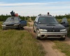
From there we took pavement to the golden spike. Asked a few questions at the visitor center and filled up our water jugs. Followed the original transcontinental railroad route/Massey trail as best we could but there are quite a few bypasses now. For instance the road in the picture below is closed to motorized traffic. It follows the northern edge of the salt lake basin and crosses roughly the western third of Utah. There are a lot of mountains/rock formations along the way. We drove up to the top of Crocodile Mountain and Loco(?) mountain and camped near that peak. Wednesday morning we finished the railroad route. For the most part it's an easy gravel road. All of the former trestles are blocked though, they were all fairly small so the trail just makes little jogs down and across and back up out of little washes. Most of these are smooth, many of them are fun, but a few are washed out badly enough to cause a challenge for something with lower clearance. We then headed south on Massey northern #10. The start of this has some fun sections and a lot of cross ditches and some good scenery. We drove around and through Silver and Crater islands. Both fun and scenic. The northern end of Silver island was part of the ill fated Donner party's route. The southern end of Silver island has a lot of campsites and side trails and some traffic. This was a consistent sign we were getting close to pavement. We got food and gas in Wendover. Introduced myself to a French man at the grocery store who'd shipped their RV to the eastern US/Canada and had driven across to UT, heading to the west coast, then back across the southern US and Mexico on a yearlong trip with his wife and daughter.1 point
-
Trip report, going to break this up into a few posts. Our first destination was the Killpecker sand dunes in SW Wyoming so we got off the interstate a little ways east of there and headed for some routes I downloaded off gravelmap.com. Site is mainly for mountain bikers to share unpaved routes but most of them seem to be gravel roads, figured it was at least a starting point to finding an unpaved through route to the dunes, can easily download GPX files off the site. Not long after leaving the interstate we stopped to make PB&Js and an old man in a Toyota pickup rolled up. At first we assumed he was mad at us for some reason but eventually realized he was just bored and wanted to chat and possibly help us figure out where we were going, which we didn't want to plan too closely. Told us the nearest paved road was 80 miles north and one 50 miles west or something which sounded good to us. Had the Wyoming gazeteer and some other ancient falling apart Wyoming map he was referencing. Noticed there was a switch on the dash to bypass the clutch safety switch, apparently this is a common thing on Toyotas, pretty cool. Saw some antelope and wild horses. Eventually made it to the campground at the dunes around sunset and decided it'd be best to camp the night first and test out the dunes in the morning. We'd forgotten flags for the dunes but fortunately B had a couple of just the orange flags he'd picked up off some trail. We zip tied those to tent poles closed in the windows along the B pillars. There were some big hill climbs on the back side of the campground B had noticed the night before but we decided to hit the dunes first. Most of the dunes were fairly solid but there were definitely some soft areas. Some variety of surfaces too, some rocky parts, quite a bit of grass and brush growing in the low flat areas, even some ponds. Some interesting rock formations along the northern edge. Saw some small rodents running around on them, would see a lot more throughout the week. I did eventually get the Impreza stuck in some soft sand driving too slow. I was able to lock the center diff but all that did was get all four tires spinning and sink the front in. The folding sand ladders got sucked in by the tires but started wrapping around them in the wheel wells. We jacked the car up, pushed some sand and the ramps under the tires, let it back down, and I got back on the move. Having the easy install square foot base for the high lift was a big plus here. The dunes cover 10,000 acres, in three or four hours we maybe covered a quarter of them. Definitely our favorite dunes we've visited but we haven't driven Glamis yet. We headed down behind the campground and checked out Crookston Ranch. I tried a couple of the big hillclimbs. Started in second gear high and then downshifted to first but that was still slowly losing speed so I tried low range and that just spun the tires. I think with a better power to weight ratio it probably could have held first gear high range and powered to the top. Fairly impressed it almost made it to the top though, those were some big loose hillclimbs. Next we drove to Boar's Tusk. B's Viair compressor fuse was still conducting but had melted itself and the little protective rubber cap. Made some PB&Js and hiked up to the base of the rock. Cool view from up there, walked around to the SW side which had a little easier path down and better view of the rock formation. Checked out a couple of groups of petroglyphs. White Mountain petroglyphs was easy to find. As we pulled up, a couple was walking back to their truck. When I got out of my car the guy says “USMB?”. We laughed and chatted a bit. He said he tested the original SJR lift kits on his Brat. Cedar Canyon petroglyphs took quite a while to reach, we knew where it was but none of our GPS maps was completely accurate. This is a common occurrence everywhere we go off pavement, disappointing sometimes but also adds to the adventure. Before we found the petroglyphs we found a cool little slot canyon. At the petroglyphs we were running low on fuel and far from any civilization so we dumped our gerry cans in our tanks. B has a three gallon can and I recently got a five gallon can. Then we decided to head west. There was a large north south ridge blocking our way west of Killpecker creek. A couple maps showed a road that went over it so we tried that and it completely disappeared when it got to the base of the bluffs. We then took some more major roads southwest. Dropped into the Alkali creek valley and then back out via a short but steep hillclimb, not sure B appreciated this detour since we were both running low on fuel but it worked out. Drove down to Green River, Impreza's low fuel light was on, so I guess that works. I had seen a bridge on the map over the Green River along a minor road so we decided to see if we could cross there. Headed back north and camped for the night because it was starting to get dark. B noticed some faint streaks of red in the sky and our phones captured some grossly exaggerated images of the northern lights. Tuesday morning we drove around the ODI plant and got to the Green River. Took at least one road/trail that was two track and eventually zero tracks. Followed it on the GPS for a while just basically driving through scrub desert until we found it again. Some other trails that weren't on our maps linked up with it. The whole time we were getting closer to the ODI plant which had a huge fire burning next to the main plant. Apparently this is just a Tuesday at the ODI plant, no one appeared to be trying to put it out. Made it up to the bridge, which still exists, but has been closed for a while. We went south to the bridge near the ODI plant and took I80 to 30 and headed for some Massey trails in Utah.1 point